
By Sergio Velásquez – IDP
GEOFIT project represents a challenge and an opportunity for a geothermal based retrofitting of existing buildings. It covers several disciplines in terms of the processes developed and the data provisions at architectural, physical, geographical, technological, contractual, economical and life cycle levels.
In general terms, physical and energetic assessment is required to start a correlated retrofitting strategy aimed to improve the energy efficiency of an existing building. At the same time, the participation of different actors and disciplines are based on technical appreciations and judgements following a segmented timeline which provides a planning strategy to be considered complex in terms of the diversity involved. The strategy must be quite clear because different actors are playing to get the objectives from different expert disciplines and an integrative standardized methodology must be implemented because the sources of information are also diverse.
Expert disciplines:
-
-
- Architecture
- Geology
- Geothermal analysis
- Drilling
- GIS
- Heat exchange
- HVAC
- Mechanical, electrical and piping
- Heat distribution
- Control and monitoring
- Economical
- Contractual/legal
- Construction/installation
- Commissioning
-
Information sources:
-
-
- Building owner
- Geographical data provider
- Geological data provider including drilling information (boreholes)
- Geothermal systems design
- Geothermal heat exchange design
- Energy analysis, simulations and optimization (building)
- Heat exchange and distribution design
- Regulatory framework and permits
-
These two paths have been integrated with a common Integrated Design and Delivery Solution methodology (IDDS) that has made possible to define the BIM execution plan. The execution plan brings together actors and disciplines and states the information exchange requirements aimed to facilitate the integration within a GEOBIM platform by using open standards and Industrial Foundation Classes (IFC-4).
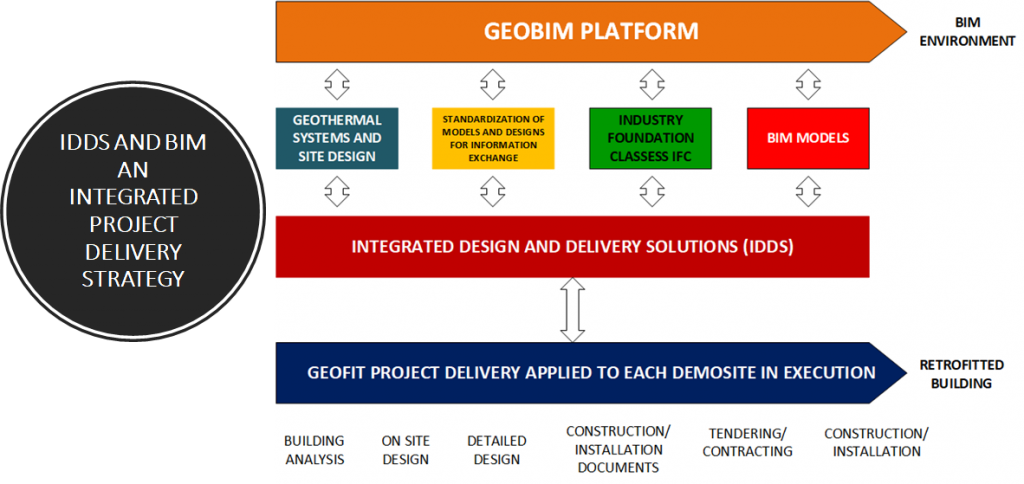
GEOBIM concept is an integrated environment where architect (defined in terms of BIM -Building Information Modelling) and geographical information covering the geothermal conditions of the building site, come together. It is expected that BIM data coming from different CAD formats and translated into IFC-4 can be reused in geographical applications – BIM to GIS solutions. This is another challenge to be solved by GEOFIT project because there are many differences between BIM and Geo data formats. With respect to geographical information, CityGML and LandInfraGML are the most common standards and BIM is defined in IFC format within GEOFIT project. The main outcome is two geometrically model of identical objects, adding attributes (metadata) and level of detail to the objects in both development environments and use compatible open standards.
GEOBIM concept is an integrated environment where architect (defined in terms of BIM -Building Information Modelling) and geographical information covering the geothermal conditions of the building site, come together. It is expected that BIM data coming from different CAD formats and translated into IFC-4 can be reused in geographical applications – BIM to GIS solutions.
GEOBIM integration has been thought as a solution for the GEOFIT demo sites management covering the multidimensional concept of BIM, nevertheless, to import BIM data into geographical information systems is not a trivial task. The seven dimensions are: Geographical location, vector information (planes, drawings and available documentation), three-dimensional rendering of the buildings, duration and timing analysis – scheduling, cost analysis, sustainability assessment, lifecycle, and facility management and control beyond building occupancy. IDP supports the GEOFIT partnership to create this integrated environment providing a right decision making tool among all of the potential solutions along the geothermal facility lifespan of the project.